Saturday, July 16, 2011

Classed chloropleth Map


http://www.buzzfeed.com/jonah/suicide-maps-charts-and-graphs

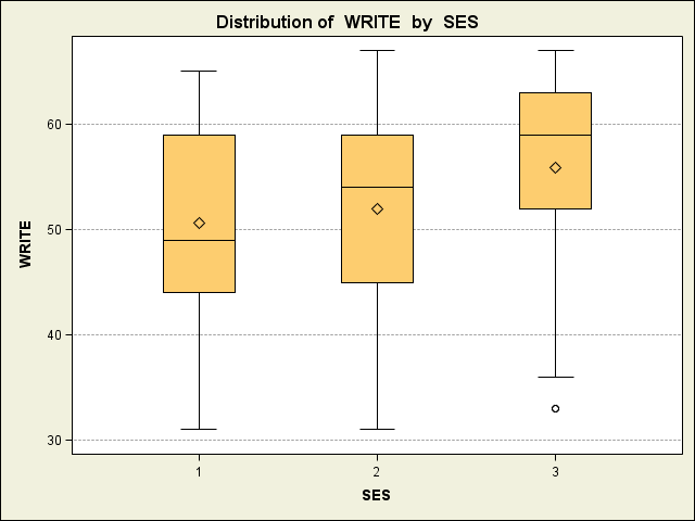
This is an example of a classed chloropleth map which uses different classes to allow us to see difference in values around a region.  As we see above there are different categories to illustrate the numbers of suicides in white men per 100000 living people.  Different colors are used to signify each of the classes as well.

Unclassed Chloropleth Map


http://www.princeton.edu/%7Ervdb/JAVA/election2004/purple_america_2004_small.gif

This is an example of the unclassed chloropleth map which uses a special frequency curve that varies intensity from the lowest to the highest values.  It uses different color schemes, colors and shades to illustrate this.  Above we see the red coloration representing the more Republican counties while the blues are the Democrats.

Bivariate Chloropleth Map


http://rkpjrhist615.wordpress.com/category/geography-310/

Above is the epitome of a Bivariate Chloropleth map which is used to analyze two different variables visually and it allows us to try and make a correlation between two factors.  We can look at two different data sets that would not present the information we may want if they were alone, but together we can clearly see this.  Above is an example that is mapping poverty levels and the population with less than high school education.

Univariate Chloropleth Map


http://www.sixsteps.org/2006/04/

This is an example of a Univariate Chloropleth Map which is used to analyze one variable.  It uses standard classification methods, but is not quite as detailed.  Above we can clearly see the distribution of different religions across the United states and we can see where they are more prominent as opposed to other regions.. 

Standardized Chloropleth Map


http://blogs.sas.com/jmp/index.php?/archives/22-Support-Files-for-Tuning-Graphs-Presentation.html

This is an example of a standardized chloropleth map is different from the unstandardized in that the information is aerially averaged such as with density.  It is efficient and good to use because the data is presented in a efficient manner.  The above illustration shows hazardous waste site installations after being averaged.

Unstandardized Chloropleth Map


This is an example of an unstandardized chloropleth map which illustrates the raw numbers when displayed, rather than being averaged out.  It shows an unstandardized chloroplate that is represented as a total value.  This above illustration  is a perfect example.

Nominal Area Chloropleth Map


http://www.ilstu.edu/~jrcarter/Geo204/Choro/Tom/calif-correct-4-quartiles%7B2%7D.gif

This illustrates an example of the nominal area chloropleth map which is a type of chloropleth map used to display nominal data which are items that are typically categorical.  When we say categorical we mean that they belong to a specific definable category such as colors, ethnic groups, or religious groups.  Above is an example in California with the percent of black condo owners who live there being plotted.

Bilateral Graph Map


http://sworlandoblog.com/2008/04/01/orlando-has-the-most-number-of-vacant-homes/

Above is an example of a bilateral graph which is used to depict any increases on one side of a zero line and then decreases on the other.  Bilateral graphs display data when there is both positive as well as negative values.  Above we see it as it applies to supply and demand.

Lorenz Curve Map


http://www.maxi-pedia.com/lorenz+curve

This is an example of the Lorenz Curve which shows the cumulative distribution function of the empirical probability of the distribution of wealth.  In essence it is a graph showing the proportion of this distribution that we assume by the bottom percent of the values.  Above it shows income distribution with the percentage of population on the x axis and the actual income as a result on the y.

Index Value Plot Map


http://www.forecasts.org/cdollar.htm

This is an example of index value plot which is used as another type of visualization map.  The actual value of the index value is not absolute zero is then plotted on a line graph.

Scatterplot graph


http://www.texample.net/tikz/examples/scatterplot/

The above illustration is a scatterplot which is commonly used in statistics and is used to show correlations between two different variables in a set of data.  The value of one variable determines the position on the horizontal axis.  Above is a distribution that clearly shows as education levels increase so does income for most cases and it has a positive correlation.

Population Profile Map


http://www.census.gov/history/www/reference/maps/population_profile_maps.html

This is an example of a population profile map illustrates the number of people in a region as a function of their  age.  Above is a population profile for Texas.  it breaks down different ages and that way you can compare results for each of the age groups more readily.

Climograph Map


http://geography.ridley.on.ca/CGC1D/Students/Quebec2/Geo./Climographs.htm

This is an example of a climograph which is a graphic way of depicting the monthly precipitation and temperature for an area of interest.  It is shown as a bar graph for the precipitation aspect and a line graph for the actual temperature.  It is a monthly average for both typically and is used to quickly view the climate.

Windrose Map


http://en.wikipedia.org/wiki/File:Brosen_windrose.svg

This is an example of windrose above which is used to give a view of how wind speed and direction are distributed in a certain location.  History wise these preceded the compass rose because there were no differentiation between "cardinal direction" and the wind that blew from a direction.  It uses a polar coordinate system to grid frequencies and the direction with the longest spoke shows the direction of the wind with the highest frequency.

Triangular Plot Map


http://ex-parrot.com/~chris/wwwitter/20050407-it_doesnt_matter_how_you_vote_either_way_your_planet_is_doomed.html

This is an example of a triangular plot which is used to graph three variables and is most often used to show relative compositions of things such as rocks and soils, but can be applied to any system with three variables and three only.  The proportions of the variables plotted always sum to the some constant and the vertex represents a 100% proportion of the variable to the left and 0% to the right.  As any one of the proportions increase in one variable the point also moves from the base to the opposite side of the triangle.

Parallel Coordinate Map


http://www.geovista.psu.edu/publications/JSM99/Image53.gif

This is an example of a Parallel Coordinate Graph which is used to visualize high dimensional geometry and analyze data specifically multivariate.  It shows a set of points in a n dimensional space, with a backdrop, and the lines are typically vertical and equally spaced.  A point is represented then on a poly line like above and the position of the vertex on the i-th axis corresponds to the i-th coordinate of the point.

Histogram Map


The above illustration is known as a histogram and is used to graphically represent the distribution of a data and is an estimate of the probability distribution of a continuous variable.  It contains frequencies shown as rectangles and has an area equal to the frequency of the observations in the total interval.  The height of these are equal to the frequency density of the entire interval as well. 

Boxplot Map


http://www.ats.ucla.edu/stat/sas/faq/sas9_stat_plots.htm

This is an example of the box plot which is commonly used in mathematics and is used to conveniently depict groups of numerical values in a way called the five number summary.  This includes the smallest value, the lower quartile, the median, the upper quartile, and the largest value.  We come across this alot especially in statistics.

Stem and Leaf Plot Map


.http://www.studyzone.org/mtestprep/math8/f/stemandleafl.cfm

This is an example of the stem and leaf plot which is used commonly in mathematics and its purpose is to assist in visualizing the appearance and shape of a certain distribution of values.  It is common in statistics for presenting quantitative data graphically.  The stem and leaf plot is similar to the histogram as well.

Similarity Matrix Map


http://www.biomedcentral.com/1471-2164/8/353/figure/F5?highres=y

The similarity matrix model are used in sequence alignment and higher scores are given to more-similar characters, while the lower ones (negatives) are for the not so similar characters.  Matrices that are alike represent the same linear transformation under two differing bases.  Above is an example to represent this in a cartographic manner.

Correlation Matrix Map


http://www.thevirtuouscircle.co.uk/REPORTS/CSR%20-%20the%20heart%20of%20business/achieving%20html%20folder/achieving%20high%20performance.html

Above is an example of a correlation matrix which is used to compare the different values and correlations from all pairs of data sets.  It involves statistics and the element in row j and column k is equal to the correlation coefficient between the random.

Star Plot Map


http://visalix.xrce.xerox.com/index.php?page=help

This is an example of a star plot map which is any cartographical representation of the stars, galaxies of surfaces of the planets as well as the moon.  Many maps today are based on a coordinate system and are compiled from a compiled number of cartographic observations.  This is made with different instruments carried on board a space craft.

DOQQ Map


http://www.utexas.edu/depts/grg/hudson/grg360g/EGIS/final_project/spring04_projects/web_justin_reynolds/Lake%20Travis.htm

This is an illustration of a DOQQ map and is used to digitize an image of a photograph (aerial) and corrected for displacements caused by various camera angles and relief.  It is spatially accurate with the different planimetric features appearing in their true geographic positions on the planet.

DEM Map


http://asterweb.jpl.nasa.gov/gdem.asp

This is an example of a DEM map which is used to show the digital elevation of the earth.  Each of the pixels also are representative and coordinated to world space(longitude and latitude) and represents some amount of that space depending upon the purpose of the model..  It shows different arrays of elevation levels and values that represent their ground positions at regularly spaced intervals.

DLG Map


http://www.mapcruzin.com/free-geodata-shapefiles/usgs-geospatial-data-geodata-geographic-download.htm

Above is an example of DLG map uses a format that stores vector data in ASCII or binary files.  It is used by some applications such as AutoCad as well as other CAD software and converted into ARC/INFO.  This is a perfect illustration of this with Illinois and Missouri.

DRG Map

http://ghostdepot.com/rg/maps/index%20map%20other.htm

Above is an example of a DRG graphic which is a scanned image of a 7.5-minute topographic map and the image is georeferenced to the surface of the earth (UTM). It is used to to collect, review, and revise other digital data, especially digital line graphs.  As illustrated above this is an example in Colorado.

Isopleth Map


http://dwb4.unl.edu/chem/chem869v/chem869vlinks/weather.about.com/newsissues/weather/library/weekly/aa071600a.htm


The above illustration is an example of an isopleth map which shows a line on a Cartesian nomogram where all the points represent a certain value of a variable.  An example of this could be an isobar on an isopleth and each of these lines have points along them of equal value. Above is an example as it would apply to the United States.

Isopach Map


http://higheredbcs.wiley.com/legacy/college/levin/0471697435/chap_tut/chaps/chapter10-06.html

Above is an example of a isopach map which is used to show different variations in thickness within a certain stratum.  These are also contour lines that show equal thickness over an area and are utilized many times in sedimentology, stratigraphy, as well as volcanology.  Above is an illustration over the North Eastern United States.

Isohyets Map


http://www.csulb.edu/~rodrigue/geog442/labs/gnatcatcherlab.html

Above is an example of the isohyet map which is used to illustrate rainfall on a map.  It is a line drawn on a map keeping points connected together that are equal in value.  Above is an example of this in California.

Isotach Map


http://www.al-struct.com/?m=06

This is an example of an isotach map is used to connect different points on a map with the same wind speed. Equal values lie along the same line which makes it easy to view the wind speeds being that they are grouped already as opposed to individual points.  Above is an example laid across a map of the United States of america.

Isobars Map


http://cimss.ssec.wisc.edu/oakfield/maps3.htm

Above is an example of the isobars map which is used in today's era to signify lines of equal atmospheric pressure on a map.  Each line passes through a pressure of the same exact value so that way they are grouped together by numerical value.  Above is an example of an isobars map over Michigan.

LIDAR Map


http://urbanomnibus.net/2011/06/the-omnibus-roundup-107/

Above is an example of LIDAR  which uses an optical remote sensing technology to measure the distance to, or other properties of a target by illuminating it with light and is done so often by using pulses from a laser.  LIDAR uses ultraviolet, visible, as well as near infrared light to show images and can be used with a large number of objects including, rocks, rain, chemical compounds, etc.  Above is an illustration of the city of New York Photo Voltaic potential for solar panels across the city.

Statistical Map

http://www.bls.gov/lau/maps/twmcort.gif

This is an example of a statistical map which is used to show variation in the quantity of a factor.  This can include different things such as rainfall, population, or crops in a geographic area and a dot map is one type.  The above illustration clearly shows us unemployment rates by country across the United States and as we can see most of this occurs in the Midwest with higher concentrations around Texas.

Doppler Radar


http://www.stuffintheair.com/Doppler-radar-weather.html

The above illustration is an example of the Doppler radar system which we use today and is typically used by weather forecasters to show the location and velocity of different storms, clouds, and precipitation that form across the globe.  Doppler is used to show different phenomenon across the globe at a distance and allows us to prepare for them ahead of time and hopefully before they hit land.  Above shows the velocity of a windstorm over Canada and the different colors are used to help understand the magnitude/speed of the winds.

Black and White Aerial Photo


http://www.shutterstock.com/pic-3240699/stock-photo-an-aerial-black-and-white-view-of-midtown-manhattan-new-york.html

Above is a black and white view of downtown Manhattan, New York in a aerial black and white photo.  These are normally used not only to show a great amount of detail about landforms and vegetation, but also to permit accurate mapping of land cover as well as features understandable on regional, continental, and even global scales. Images can the be studied and compared to one another at different points in time.

Infrared Aerial Photo Map


http://www.kgs.ku.edu/Current/2002/aber/aber3.html

The above illustration as many know signifies an aerial infrared view and is used from an aerial point of view such as from a satellite, plane, or other devices, to view the ground surface.  In doing so however electromagnetic radiation with a wave length longer than visible light is utilized and it is used even by the military as well for systems such as sonar.  Above is an illustration of trees in a geographic region and certain colors give off different colors when the infrared factor is included in the equation (trees now pink as opposed to green).

Cartographic Animation Map


http://www.cg4tv.com/europe-map-animated-background.html

The cartographic animation map an provide a more meaningful view of the data through the use of different forms of data classification.  Over time it has been limited by both the difficulty of their construction, distribution, as well as how expensive it is especially during earlier times.  Above is an example and it is not used much or integrated into software for Geographic Information Systems (GIS) because it currently faces many methodological hurdles.

Cartogram


http://www.electoral-vote.com/evp2007/Pres/Carto/Dec28-c.html

A cartogram is responsible for presenting some form of statistical data in a geographical distribution on a map.  In doing so how ever many times it is in a simplified and abstracted form, usually on a distorted map base.  Above is a perfect example because those are not the exact shapes of the states, and in a way they are estimated and shapes are made simpler form wise than they are in actuality.

Flow Map


http://your.kingcounty.gov/airport/pilots/fly_quiet.stm

The above graphic is an example of a flow map which is used to signify the movement of objects from one location to another.  This can be used when it comes to movement of a good, people, or even money.  The above picture shows the movement of noise across a region and what areas have the more sensitive areas to noise.

Isoline Map


https://www.e-education.psu.edu/geog486/l6_p6.html

The isoline map, illustrated above, is typically used with continuous lines to join any points of the same value.  Some examples of this might include temperature, barometric pressure, or even altitudes/elevations.  It is used to interpret information and it makes reading a map easier because all the numbers of the same value are grouped together by a line and it is easy to see different contour levels for instance of a geographic area.

Proportional Circle Map


The proportional circle map is another common mapping tool used that is typically utilized to represent some numerical value, such as population density in a state.  The higher the value the larger the circle, and the smaller the circle of course has the lower densities.  This makes it easy to compare different states for instance to one another because you can just look at the size of the circle and measure it in comparison to the size of the other states.

Chloropleth Map


http://courses.washington.edu/info424/Labs/ChoroplethMap.html

Above is an illustration of a thematic map, which is used to show measurements of the statistical variable being displayed on the map.  Different color patterns allow us to easily visualize how a measurement varies across a geographic area, which in this case is the United States, or it shows the level of variability within a region.  The more difference between the colors then the higher the difference between their numerical value and the above picture shows the one year forecast for changes in jobs.

Dot Distribution Map


Above is a dot distribution map which is used to show the commonality or occurrence of some particular phenomenon in a region.  Many times they are used visually too show various spatial patterns.  Dots are all the same size and regions with more dots begin to form blobs and look more concentrated like on the upper right side of the United States.

Propaganda Map


Propaganda maps are difficult to describe but many times they are used for political measures.  It does not merely focus on distortion, but how the different parts of the map are put together or used.  Above is an example of this illustrating what territory John Smith believes the New World looks like and what territories belong to what nation in the area surrounding the New World.

Hypsometric Map


Above is an illustration of a hypsometric map which shows detailed elevation of a region through contour and sometimes shading.  It is responsible for showing relief of the Earth's surface and different colors represent different levels.  In the picture above the lower elevations are green while the higher ones are depicted in browns and reds.

PLSS Map


Above is an illustration of the Public Land Survey System map type which is used to survey as well as identify various parcels of land in the United States.  It is many times utilized when it comes to deeds as well as titles.  This is used not only for rural land, but also even for undeveloped as well as "wild" territory,

Cadastral Map


http://www.aabsys.com/website/cad-gis-products/topographic-mapping/topographic-&-cadastral-mapping-screenshots.htm


This illustration above is an example of a cadastral map which illustrates borders of metes and bounds real property in a country.  It includes ownership, dimensions, and the values of individual parcels of land.  It is used many times in disputes between landowners as well to solve cases.

Thematic Map


This is a perfect example of a thematic map in that it describes a particular physical, social, political, cultural, economic, sociological or agricultural aspect of a region.  Above it shows hispanic density across the United states of America.  This is illustrated through different color schemes with the darker one signifying the higher densities and the lighter and brighter showing less persons per square kilometer.

Sunday, May 22, 2011

Topographic Map


http://en.wikipedia.org/wiki/File:Hawaii_Island_topographic_map-fr.svg

Above is an example of a topographic map which simply is used to depict different levels of elevation.  Topographic maps may come in color or in black and white and the lines around it signify different elevations and as you can see depicted above the elevation increases as you move inward as indicated by the darker coloration.  It focuses on large scale detail and is not only used to show natural features, but even man made ones. (5/22)

Planimetric Map


 http://blog.justroughinit.com/avoid-getting-lost-carry-a-map/?nomo=true

This is a perfect example of a planimetric map which shows geographic entities and features of the Earth's surface in this region minus the roads, buildings as well as bodies of water which may be visible from above.   It focuses more on features such as sidewalks, streets, highways, reservoirs, tanks, airports and bridges for instance.  Illustrated above is a map that leads to Mount Washington and the planimetric map is typically used as a base map and is used interchangeably with another term known as a line map.